

Choosing a handheld boat GPS gets a lot easier once you separate true marine navigation gear from general-purpose trackers and messengers. Some of these picks are built for wayfinding on the water, while others lean hard into SOS use, tracking, or rugged backup duty. That matters on a wet deck, a long crossing, or a weekend run where battery life, button layout, and visibility can matter more than a long feature list.
Quick Look At The Strongest Picks
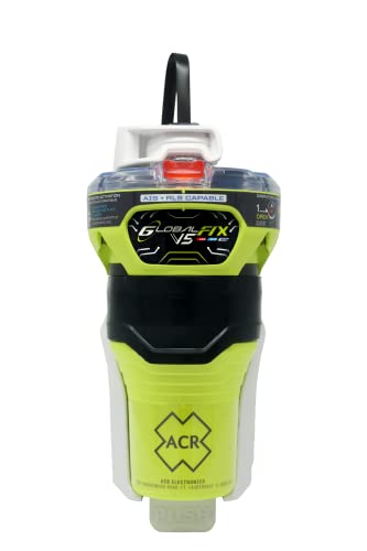
ACR GLOBALFIX™ V5 AIS EPIRB

Spot X Bluetooth 2-Way Satellite Messenger

Garmin eTrex 32x


Garmin Striker Vivid 7cv

SPOT Trace Satellite Tracking Device

Garmin GPSMAP 78S Marine GPS Navigator

More Details On Our Top Picks
Offshore-minded boaters will notice right away that this ACR unit is less about casual route planning and more about distress signaling. The CAT 2 manual release bracket gives you a fixed mounting approach, which suits a vessel that keeps serious safety gear in one known spot.
Global satellite coverage and AIS, meaning Automatic Identification System broadcasts that nearby vessels and rescue services can detect, matter most once you’re outside easy cellphone range. The trade-off is simple: this is specialized emergency equipment, so it makes more sense for bigger water and longer trips than for a short afternoon cruise.
Strong Points
- Satellite-based distress signaling reaches far beyond shoreline-only gear.
- AIS support helps nearby craft and rescue services notice the alert.
- Manual release bracket keeps the unit set in a fixed place.
- Mobile app support gives you another layer of setup and status handling.
- Well suited to boats that need dedicated emergency hardware, not a general navigator.
Things To Consider
- It’s built for emergencies, so it doesn’t serve as an everyday route guide.
- Manual-release mounting asks for a proper install spot and a little planning.
- Battery or device upkeep becomes part of regular boat readiness, which is easy to forget during calm seasons.
Feature Snapshot
Who It Suits Best
You’re the best fit here if your boating includes offshore passages, remote waters, or a dedicated emergency locker on board.
Where Another Pick Suits Better
Garmin GPSMAP 78S Marine GPS Navigator is a better fit for you if you want a more everyday chartplotter-style handheld for routine boat positioning.
The Spot X sits in the middle ground between a marine emergency beacon and a practical travel messenger. Bluetooth pairing makes setup easier from a phone, which is handy on a dock, in a tow vehicle, or during trip prep at home.
That two-way messaging ability is the real story here, because you can send and receive short updates where a regular GPS unit only shows location. The subscription requirement is the trade-off, so this one fits better for people who truly expect to use satellite messaging, not just keep it as a backup.
What We Like
- Two-way satellite messaging gives you a real back-and-forth channel.
- Bluetooth support makes pairing and setup less fiddly.
- SOS function adds a clear emergency communication path.
- Handheld format works well for travel bags, deck kits, and road trips.
Worth Noting
- A subscription is part of the ownership picture, so ongoing use matters here.
- It’s more communicator than boat chart tool, which narrows its role on the water.
- Regular charging and message-plan management take a little upkeep.
Core Details
Built With In Mind
You’re a strong fit for this model if you split time between boating, travel, and places where cell coverage fades out.
Skip It When
Garmin eTrex SE makes more sense for you if your main need is straightforward handheld GPS use with less emphasis on messaging.
Compared with the satellite-first Spot X, the Garmin eTrex 32x feels like a straighter navigation tool for trail-and-water crossover use. Its rugged handheld build suits a damp deck bag, a tackle box, or a glove compartment without much fuss.
You may find the appeal here in the lower-stress routine tasks, like marking a point, checking where you are, and carrying a compact backup unit. The honest read is that it’s less flashy than the message-driven picks, yet that can be exactly why it earns a place in a boat kit.
Highlights
- Rugged handheld design suits rougher storage and transport.
- Compact size makes it easy to keep as a backup unit.
- Works well for simple wayfinding without extra communication extras.
- Good fit for mixed outdoor use, not only boating.
Room For Improvement
- It’s a more traditional handheld, so it lacks the richer marine messaging found on the Spot X.
- Screen and control style are geared toward utility, not a large visual layout.
- Older-style handheld GPS setup may feel plain beside newer feature-heavy units.
Technical Sheet
The Right Fit
You’re best served by this one if you want a dependable, compact handheld for basic route awareness and backup duty.
A Better Fit Elsewhere
Garmin GPSMAP® 67 suits you better if you want a higher-end handheld with a larger display and expanded navigation capability.
The eTrex SE follows the same compact handheld idea as the 32x, but it leans harder into battery endurance and connected planning. A 2.2-inch display is small, though it also helps keep the unit easy to stow in a dry bag or center-console compartment.
Multi-GNSS means it can draw on more than one satellite navigation system, which helps in tougher locations where a single network can be less dependable. Pairing with Garmin Explore is useful for trip prep and route management, and the long battery claim gives this one a strong case for long weekends or extended day runs.
Upsides
- Long battery runtime suits extended use away from a charger.
- Multi-GNSS support helps in tougher coverage conditions.
- Bluetooth pairing makes route planning more convenient.
- IPX7 water resistance gives you a practical margin against splashes and brief submersion.
- Small body stores neatly in tight boat compartments.
Softer Spots
- Small display size asks for careful attention during setup and map checks.
- The compact format can feel less relaxed for long on-screen sessions.
- Bluetooth and app use add another layer of charging and phone pairing to manage.
Details At A Glance
Whose Shelf It Belongs On
You’re the best match for this model if you want a small, sturdy handheld for frequent day use and longer stretches between charges.
Reach For A Different Pick When
Garmin GPSMAP 78S Marine GPS Navigator suits you better if you want a more classic marine chartplotter-style unit for boat-first navigation.
This Garmin belongs in the conversation because it’s less a pocket navigator and more a helm tool for fishing and in-boat awareness. The 7-inch color display gives you room to read sonar and map details without squinting, which helps in a bouncing center console or a bright open cockpit.
It also includes a GT20 transducer, meaning the sensor that sits in the water and sends sonar pulses back to the unit, so you get traditional CHIRP sonar and ClearVü scanning sonar in one setup. The trade-off is obvious: this is a boat-mounted electronics piece, not a handheld you tuck in a jacket pocket.
Bright Spots
- Large 7-inch display is easier to read at a glance.
- CHIRP traditional sonar and ClearVü scanning sonar cover two useful views.
- Built-in GPS helps with waypoints, routes, and speed readouts.
- Quickdraw Contours supports custom mapping for familiar water.
- Bailmount bracket included, which simplifies installation on a boat.
Areas To Watch
- It’s a fixed marine setup, so portability is limited.
- The feature set is broader than a simple handheld navigator needs.
- Owners who only want basic point-to-point directions may find the sonar focus more than they need.
Core Details
Perfect Match For
You’re the right fit here if your boat time centers on fishing, sonar reading, and a fixed screen at the helm.
Another Choice May Suit
Garmin eTrex SE fits you better if you want a much smaller handheld with lighter carry and simpler day-trip use.
The SPOT Trace takes a different lane from the fishfinder above, because it focuses on tracking rather than live navigation on a screen. That makes it useful for boats, gear, or vehicles that you want to keep an eye on from a distance, especially in storage or while in transit.
For boating use, this works best as a location-awareness add-on rather than your main steering tool. The subscription requirement is worth weighing carefully, since the device makes the most sense for owners who will track something often enough to justify the ongoing service.
Best Bits
- Satellite tracking gives you location awareness beyond phone coverage.
- Compact tracker form is easy to mount or tuck away.
- Useful for boats, cars, and other valuables you want to monitor.
- Fits well into a broader safety or asset-management setup.
Minor Gripes
- It isn’t a full navigation handheld, so chart reading isn’t its main role.
- A service plan is part of owning it, which adds another recurring task to manage.
- Setup is more about placement and account management than casual grab-and-go use.
Quick Facts
Who Should Grab It
You’re the best fit for this model if your priority is monitoring a boat or vehicle, not using a full handheld navigator at the helm.
Swap It Out When
Garmin GPSMAP 78S Marine GPS Navigator is the better choice if you need a true marine chartplotter-style handheld for route guidance.
Compared with the tracker-focused SPOT Trace, the Garmin GPSMAP 78S is much closer to a true marine navigation tool. That world-wide chartplotter positioning makes it feel like a boat-first handheld, which is exactly what many small-craft owners want on a busy dock or in shifting water.
The older design language is part of the package, and that can be good or bad depending on what you like to hold. For captains who value straightforward marine orientation over phone-style flair, the honest read is that this one still has a clear job to do.
Positives
- Marine GPS and chartplotter focus suit boat navigation.
- Handheld size keeps it usable as a portable backup.
- Simple layout works for owners who prefer a direct interface.
- Fits naturally into a small-boat gear bag.
Points To Note
- Its older styling may feel plain next to newer handhelds.
- Screen size is more practical than expansive.
- It’s built around marine chart use, so it’s less versatile for mixed outdoor messaging.
Core Details
Made For
You’re a strong fit here if you want a straightforward handheld for marine route awareness and boat-side backup duty.
Look Elsewhere When
Garmin GPSMAP® 67 suits you better if you want a newer rugged handheld with a bigger display and longer battery reach.
The GPSMAP 67 sits at the more capable end of this list, and its bigger 3-inch sunlight-readable color display makes on-the-water checking easier than the smaller eTrex screens. TopoActive maps and satellite imagery also give you richer context, which helps when your route crosses shorelines, coves, or unfamiliar access points.
That expanded GNSS and multi-band support matters in difficult places, including steep country, urban canyons, and tree-dense areas where signal quality can wobble. With the rechargeable internal battery and the long runtime figures, this is the pick that feels most ready for long navigation days without babysitting the charger.
Reasons To Buy
- Large 3-inch display is easier to read in bright conditions.
- Expanded GNSS and multi-band support help in tougher locations.
- TopoActive maps and satellite imagery add useful route context.
- Long battery runtime suits extended outings.
- Rugged handheld build works well for wet, crowded boat bags.
Honest Caveats
- The richer feature set brings more setup and planning to learn.
- The larger display and map tools can feel like more than casual users need.
- It’s still a handheld, so screen space remains smaller than a dedicated helm unit.
Feature Rundown
The Right Fit
You’re the best match for this pick if you want a rugged handheld with advanced mapping, strong battery reach, and more room to grow into the system.
Where Shoppers Go Wrong
Garmin eTrex SE suits you better if you want a slimmer, simpler handheld and do not need the extra mapping depth.
How To Choose The Right Handheld Boat Gps
Match The Device To The Water You Actually Use
Boat size and range change the right call fast. A short-run lake boat can get by with a compact handheld like the eTrex SE or eTrex 32x, while offshore use pushes you toward emergency signaling gear or a more capable marine navigator. The farther you run from shore, the more you should care about satellite coverage, fixed mounting, and whether the device handles distress communication or just route marking.
Screen size matters more than people expect once glare, spray, and motion enter the picture. A 3-inch or 7-inch display gives you more breathing room than a tiny screen, but the larger units are less pocketable and usually less casual to carry. That trade-off is easy to accept on a helm, less so in a day bag.
Look Past The Word GPS And Read The Job Description
“GPS” can mean a simple handheld navigator, a marine chartplotter, a tracking device, or a satellite messenger. Those are very different tools, even though they all touch location data. The Spot X and SPOT Trace lean into communication and tracking, while the Garmin marine units focus more on wayfinding and chart use.
Think about the moment you want solved. Do you need to mark a waypoint, send a message, monitor a boat in storage, or keep a rescue signal ready? Once that answer is clear, half the shortlist drops away on its own.
Battery, Water Resistance, And Mounting Change Daily Use
Battery claims matter most on long days away from charging. The GPSMAP 67 and eTrex SE stand out for longer stretches, while the Striker Vivid 7cv depends more on boat power and installation. Water resistance also deserves attention, because wet hands and spray are routine on the water, not edge cases.
Mounting style changes ownership just as much as battery life. A manual release bracket or a tilt/swivel bailmount suits fixed boat storage, while handheld units stay easier to move between boats, trucks, and dry storage. The right answer is the one that matches how you actually launch, stow, and use your gear.
What To Weigh Before You Click
Mistakes Worth Dodging
A common slip-up is treating every handheld as a marine navigator. A tracker like SPOT Trace serves a very different role from a chartplotter-style unit like the Garmin GPSMAP 78S, so the feature mix has to match the job. Another mistake is overlooking the service plan or satellite subscription, which changes the long-term commitment more than the initial gadget price does.
Storage gets ignored too often. Boat gear lives in damp spaces, bouncing compartments, and busy cabins, so compact size, water resistance, and a screen that stays readable in daylight all matter. A unit that looks ideal in a quiet living room can feel awkward once it’s exposed to glare and movement.
Where The Extra Money Goes
Higher-tier units usually spend the extra budget on better positioning support, stronger displays, longer battery life, or richer mapping. On the Garmin GPSMAP 67, that means a larger sunlight-readable screen, expanded GNSS, multi-band support, and longer runtime, all of which help on longer or trickier routes.
You also pay for convenience features that smooth real use. Bluetooth pairing, app syncing, and custom mapping tools save time during planning and make the device easier to live with, especially for frequent trips. Those extras are worth it when boating is a regular habit, not a once-a-season outing.
Closing Thoughts
Your best handheld boat GPS depends on how you use the water, not just how many features a listing can stack on the page. Emergency-focused gear like the ACR GLOBALFIX™ V5 belongs to serious offshore readiness, while the Garmin eTrex line suits portable navigation, and the GPSMAP 67 brings the most room to grow. Choose the tool that matches your route, your storage space, and your tolerance for charging and setup, and the rest gets much simpler.