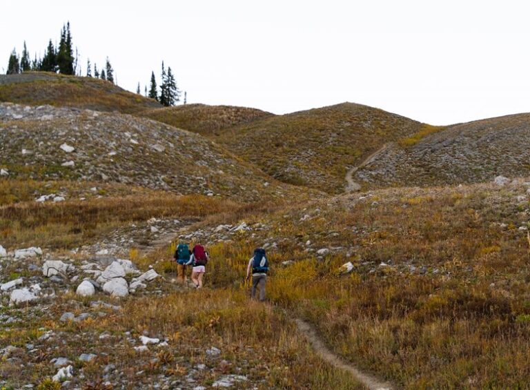

Hiking with shaky phone service gets old fast, especially on long routes, wooded ridges, or trips where you want a clearer picture of where you are and where you’re headed. The right handheld GPS unit keeps route checks, waypoint marking, and battery planning much calmer on the trail. Some of these picks lean hard into rugged navigation, while others make more sense for people who want messaging, mapping, or a simpler button-first layout. The short list below keeps those differences plain so you can match the device to your kind of hiking.
Quick Trail Shortlist At A Glance
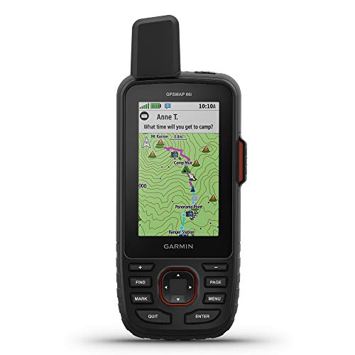
Garmin GPSMAP 66i, GPS Handheld and Satellite Communicator
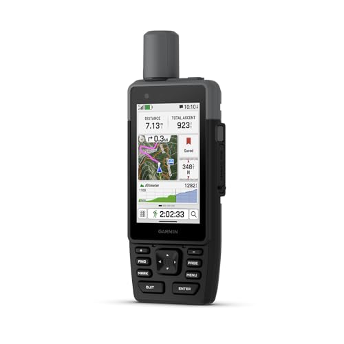
Garmin GPSMAP H1, Premium GPS Handheld Navigator

Garmin eTrex 32x, Rugged Handheld GPS Navigator

Garmin eTrex SE, GPS Handheld Navigator

Spot Gen 4 Satellite GPS Messenger

Garmin GPSMAP 65s, Button-Operated Handheld with Altimeter and Compass

BEVA GPS Land Measuring Instrument

Garmin GPSMAP 79sc, Marine GPS Handheld
The GPSMAP 66i suits hikers who want a navigation tool that also handles trail communication. TopoActive mapping gives you an onboard map layer, so route checking feels less like guesswork on wooded approaches or unfamiliar ridgelines. The inReach side adds a second layer of usefulness for remote trips, especially where your phone turns into a paperweight.
The honest read is that this is more device than a casual weekend stroll needs. That extra capability also means you’re carrying a more specialized tool, so it fits best for people who go far enough off-grid to care about more than simple breadcrumb guidance.
Strong Points
- Combines navigation and satellite messaging in one handheld, which cuts down on pocket clutter during long days out.
- TopoActive maps help you read routes directly on the unit instead of leaning on a phone signal.
- Works well for remote trail use, where having a dedicated communicator can matter more than a slim profile.
- Good match for hikers who want one device to cover both direction-finding and check-ins.
Things To Consider
- The feature set is broad, so new users may need a little time to learn the menus and message functions.
- It brings more complexity than a basic waypoint-only handheld, which can feel unnecessary on short local hikes.
- Owners typically need to stay on top of setup and mapping preferences to keep the unit feeling smooth in use.
Feature Snapshot
Who It Suits Best
Backcountry hikers who want mapping and satellite messaging in one unit will get the most from this pick.
Where A Sibling Pick Shines
Garmin eTrex SE suits hikers who want a simpler, lighter-feeling navigation unit without the messaging layer.
The H1 stands out because it mixes a touchscreen with physical buttons, which gives you two ways to work through menus in wet gloves or cold conditions. Preloaded maps suit hikers who want to get moving fast, and the long battery life emphasis makes sense for people planning full-day outings or longer sections of trail. It feels more polished than the eTrex units, though that polish usually comes with a more deliberate learning curve.
You may find it especially helpful on routes where route changes happen often and a faster interface saves frustration. The trade-off is straightforward, this is a premium navigation choice, so the extra comfort is most useful for hikers who spend enough time with the device to appreciate it.
What We Like
- Touchscreen plus buttons gives you flexible control in changing weather and while wearing gloves.
- Preloaded maps remove part of the setup work before a trip starts.
- Battery emphasis makes it a sensible fit for long trail days and multi-stop outings.
- Feels well suited to hikers who prefer a modern interface without giving up physical controls.
Room For Improvement
- The interface is more advanced than basic trail units, so first-time handheld GPS users may need a little patience.
- Its premium positioning may feel like overkill for short neighborhood hikes or casual park walks.
- Touchscreen gear often needs a bit more care with grime and moisture than a plain button-only shell.
Details At A Glance
Who Will Love This
Hikers who want a premium handheld with a modern interface and flexible controls are the best fit here.
Another Choice May Suit
Garmin eTrex 32x works better for hikers who want a more compact button-driven setup with less interface complexity.
The eTrex 32x keeps the shape many trail hikers still prefer, compact, button-driven, and easy to stash in a jacket pocket. That makes it a nice fit for day hikes where you want waypoint navigation without carrying a larger interface-heavy unit like the GPSMAP H1. The rugged casing also suits backpacks that get tossed into car trunks, trail bins, and muddy camp corners.
In most use cases, the appeal is straightforward: simple controls, a trail-friendly footprint, and a long-lived Garmin format that many people already know how to handle. The catch is that this older-school style won’t feel as polished as the touchscreen models, so it’s more practical than flashy.
Best Bits
- Compact shape makes it easy to carry alongside snacks, maps, and layers.
- Button layout stays straightforward for people who prefer direct physical controls.
- Rugged build suits rough pack storage and regular trail handling.
- Good middle ground for hikers who want a proven style without extra interface complexity.
Minor Gripes
- The smaller, old-school design may feel plain next to the more feature-heavy GPSMAP units.
- Physical buttons are reliable, but they can feel slower than touch input for some menu tasks.
- Keeping the screen and shell clean after dusty trail use still takes a bit of routine care.
Core Details
The Right Fit
Day hikers and straightforward route planners who want a compact button unit will feel at home with this model.
Where A Sibling Pick Shines
Garmin GPSMAP 66i is the better match for hikers who also want satellite messaging and richer onboard mapping.
The eTrex SE leans into long battery life, multi-GNSS support, and Bluetooth pairing with Garmin Explore, so it makes sense for hikers who want a lower-fuss setup that still feels current. Multi-GNSS means it can work with more than one satellite system, which can help with coverage in tricky terrain or under tree cover. The 2.2-inch display stays small, so you’re trading screen size for a lighter, more pocketable form.
That trade-off is sensible for weekend hikers and travel-friendly packing, especially when the trail plan is more about steady navigation than constant map viewing. It is not the most spacious display in this lineup, but the battery focus and simple format make it easy to appreciate on long days.
Upsides
- Up to 168-hour battery figure supports extended time away from a charger.
- Bluetooth pairing with Garmin Explore helps with trip planning and route management.
- IPX7 water resistance is a practical comfort in rain, creek crossings, and damp pack storage.
- Small size works well for hikers who want less bulk in a pocket or side pouch.
- Multi-GNSS support adds flexibility in changing terrain.
Points To Note
- The 2.2-inch display is compact, so map viewing will feel tight compared with larger handhelds.
- Bluetooth features add convenience, though they also introduce a little more setup work than a pure button unit.
- Smaller devices can be easier to misplace in a busy pack, so storage habits matter.
Feature Card
Built With In Mind
Weekend hikers and long-battery planners who want a compact, travel-friendly handheld should feel comfortable with this one.
Look Elsewhere When
Garmin GPSMAP H1 suits hikers who want a larger, more flexible interface for frequent map checking.
The Spot Gen 4 is less about detailed trail mapping and more about simple satellite messaging, which makes it useful for hikers who want a small communication layer without stepping up to a full navigator. That focus keeps the device purpose-driven, especially for camping trips or backcountry travel where a basic check-in tool feels more relevant than extra map detail. The subscription requirement is the big practical trade-off, so it suits hikers who know they’ll use the service often.
Compared with the Garmin GPSMAP models, this one asks you to think in terms of communication first and navigation second. For people who already carry maps or know their routes well, that split can make sense, but the ongoing service piece is worth planning around.
Highlights
- Satellite messaging focus keeps the function set simple and specific.
- Compact handheld format is easy to pack with layers and food.
- Works well for hikers who want routine check-ins on longer outings.
- Less cluttered than a full-featured navigation unit.
Worth Noting
- Subscription required, so the ongoing service piece needs to fit your travel habits.
- It is not built as a map-heavy trail navigator, so some hikers will want a separate GPS unit.
- Keeping it ready for travel means watching both battery status and service setup before longer trips.
Technical Sheet
Whose Shelf It Belongs On
Backcountry travelers who want message sending more than mapping will get the most from this satellite messenger.
Where A Sibling Pick Shines
Garmin GPSMAP 66i is the stronger fit for hikers who want both satellite messaging and a more complete GPS map package.
The GPSMAP 65s leans hard into trail precision, with multi-band technology, expanded satellite support, and built-in altimeter and compass tools. Multi-band means it can work with more than one signal band, which helps on routes where tree cover or terrain can make navigation feel less stable. The 2.6-inch color display gives you a bit more breathing room than the tiny eTrex SE screen, while staying smaller than the premium H1.
That mix makes it a strong fit for route-focused hikers who care about confidence more than flashy extras. The button layout keeps the learning curve familiar, though the deeper navigation tools are best for people who actually plan to use them instead of leaving them buried in menus.
Positives
- Multi-band support gives it a more capable trail navigation profile.
- Altimeter and compass add useful field data without needing extra gear.
- 2.6-inch color screen gives better visibility than the smallest handhelds in this list.
- Button operation stays dependable for wet, cold, or gloved use.
- Expanded satellite support makes sense for hikers who spend time under mixed canopy or in variable terrain.
Areas To Watch
- The richer feature set may feel busy to hikers who only need basic waypoint guidance.
- More capabilities usually mean more setup decisions before a trip.
- Button-based systems reward a little menu familiarity, so first use can feel slower than hoped.
Quick Facts
Perfect Match For
Hikers who want a button-driven handheld with stronger navigation tools and onboard heading data are the clearest fit here.
A Better Fit Elsewhere
Garmin eTrex 32x works better for hikers who want a simpler, more compact unit with fewer moving parts to learn.
This BEVA unit sits a little outside the usual hiking-only lane, because its focus is land measuring rather than trail navigation. The source highlights support for GPS and GLONASS, which are satellite systems used for positioning, and that matters most when you want area-measurement work on mountainous land, sloped ground, or flat fields. The stated accuracy range makes it more of a task tool than a backcountry companion.
That means it suits people doing property, acreage, or field measurement more than hikers following cairns and waypoints. Compared with the Garmin models above, it’s far more specialized, and that narrow focus is either exactly right or completely unnecessary depending on your job.
Reasons To Buy
- Supports GPS and GLONASS for positioning in more than one satellite system.
- Built around land measurement use, so it has a clearer task focus than general trail units.
- Useful on sloped or uneven ground where area estimation can get tricky.
- May appeal to land managers or property users who need a handheld measuring tool.
Small Caveats
- It is not shaped like a mainstream hiking GPS, so trail features are not the main draw.
- The product information is sparse compared with the Garmin units in this roundup.
- Task-specific tools can be awkward for casual pack carry, especially on simple day hikes.
Feature Rundown
Who Should Grab It
People measuring land or acreage in uneven terrain will benefit more from this than a standard hiking navigator.
Swap It Out When
Garmin GPSMAP 65s is the better choice for hikers who want route guidance, compass support, and richer trail navigation features.
The GPSMAP 79sc makes sense for hikers who split time between shoreline paths, paddle access points, or any environment where water proximity changes the equation. BlueChart g3 coastal charts are marine-focused maps, so the device is clearly tuned for boating contexts first, then rugged handheld use second. The floating design is the standout detail, because that adds peace of mind around docks, crossings, and wet packs.
For a pure hiking setup, it is more specialized than the rest of this list. Still, for hikers who also spend time on coastal water or near boats, that specialization can be very practical, almost like carrying the right key instead of a ring full of the wrong ones.
Bright Spots
- Floating design is genuinely useful near water and dock-adjacent travel.
- Rugged construction suits outdoor carry and exposed conditions.
- Preloaded coastal charts help if your route includes marine or shoreline navigation.
- Feels more purpose-built than a general handheld that merely tolerates water.
Honest Caveats
- Marine chart focus makes it less natural for inland hikers who never leave the trail.
- Its best use case is narrower than the Garmin units aimed at general hiking.
- Water-friendly gear still benefits from basic drying and storage care after use.
Core Details
Right Fit For
Coastal hikers, paddlers, and shoreline travelers who want a floating handheld will appreciate this model most.
Not Your Match When
Garmin eTrex SE is the better fit for inland hikers who want a simpler, more trail-centered handheld navigator.
How To Choose The Right Handheld Gps Units For Hiking
Start With Your Trail Style
Your route habits should lead the search. Day hikers usually do well with a compact button model like the Garmin eTrex 32x or eTrex SE, while multi-day backpackers often get more value from larger screens, longer battery life, or satellite messaging.
Remote routes change the equation because map clarity and communication matter more once the phone signal drops away. That is where the Garmin GPSMAP 66i and Spot Gen 4 start to make more sense than a plain navigator.
Control Layout Matters More Than You Think
Touchscreens feel fast in camp, but buttons can be easier in cold rain, with gloves, or when your hands are gritty from trail dust. The Garmin GPSMAP H1 gives you both, which is a smart setup for hikers who bounce between ease and control.
Pure button units are less flashy, but they tend to stay predictable under rough conditions. That steadiness is why the GPSMAP 65s and eTrex 32x still appeal to hikers who want direct, no-nonsense input.
Battery Life, Mapping, And Satellites
Battery numbers matter most when you’re far from power and not just heading out for a quick loop. The eTrex SE stands out for long battery focus, while map-heavy units like the GPSMAP 66i and GPSMAP H1 are aimed at hikers who want more screen time and more information on hand.
Satellite support also matters in practical ways. Multi-GNSS and multi-band support can improve positioning confidence in forest cover, narrow valleys, or rugged terrain, though the trade-off is usually a more advanced setup and a higher price tier.
Match The Device To Your Real Use Case
Pick the tool that fits the way you actually move outside. If you mostly follow marked routes, a simpler handheld is easier to live with, but if you like exploring side trails, measuring land, or combining hiking with coastal travel, a more specialized unit earns its place.
The best choice is usually the one you’ll keep charged, carry often, and understand quickly. That keeps the device useful instead of sitting in a drawer like spare gear you meant to learn later.
Things Worth Knowing First
Traps First Timers Fall Into
Many shoppers fixate on screen size and skip the controls, mapping style, or battery fit. That leads to awkward ownership later, especially on wet hikes where a touchscreen-only unit can feel less friendly than expected.
Another common miss is overlooking service costs on satellite messengers like the Spot Gen 4. The device itself may suit your route, but the ongoing subscription needs to match how often you’ll use it.
When Paying More Pays Off
Higher-tier units usually cost more because they bundle better interfaces, richer map support, stronger satellite handling, or extra functions like messaging. The Garmin GPSMAP 66i and GPSMAP H1 show that pattern clearly, since you’re paying for broader capability, not just a shell and screen.
That upgrade makes the most sense for hikers who spend enough time off-grid to use those features regularly. For casual trail walks, a simpler eTrex model often covers the basics without asking you to learn more than you need.
Closing Thoughts
The right handheld GPS unit for hiking depends on how deep your trips go and how much detail you want on the device itself. The Garmin GPSMAP 66i and GPSMAP 65s suit hikers who care about serious navigation, while the eTrex SE keeps things light and practical for simpler use. If your routes stay close to town, a modest handheld may be enough. For longer, less predictable days outdoors, the added clarity is easy to appreciate.